> ## Documentation Index
> Fetch the complete documentation index at: https://developer.plugsurfing.com/llms.txt
> Use this file to discover all available pages before exploring further.
# Integrating geosearch with client maps
This guide will show you how to fetch locations and show them on a map, using data from the [**Geosearch**](/reference/searchLocationsByRadius) endpoints.
Recommended UI flow:
1. Use radius or rectangle search to render map pins.
2. Use connector and EVSE fields from the search response for basic filtering.
3. When the user opens a pin or charger detail page, call [Get location by id](/reference/getLocationById).
4. Display prices from the detail response. If price is absent, show "Price temporarily unavailable."
Most client-side map libraries offer an `onRegionChangeComplete` event or similar, which is triggered when the user moves the map.\
This event should contain data for the current map position like `latitude`, `longitude`, `longitudeDelta`, `latitudeDelta`.
To get the correct amount of locations and aggregations, you need to know the `aggregationPrecision`, `latitude`, `longitude` and `distance`. Fortunately all of this can be retrieved or calculated from the map's `Region` data.
Let's look at the main function that will handle that. This sample code is written in TypeScript, but the logic will be the same in all programming languages.
```ts theme={null}
// This function calculates the necessary data and fetches locations from the Geosearch endpoint
async function getLocationsForRegion(region: Region) {
// get data from the map region
const { latitude, latitudeDelta, longitudeDelta } = region;
// calculate the distance for latitudeDelta
const latDistance = (latitudeDelta / 360) * 2 * Math.PI * EARTH_RADIUS;
// calculate the distance for longitudeDelta
const lonDistance =
(longitudeDelta / 360) *
2 *
Math.PI *
EARTH_RADIUS *
Math.cos((latitude * Math.PI) / 180);
// use the larger of the two distances
const distance = Math.max(latDistance, lonDistance);
// calculate aggregation precision based on latitude delta
const aggregationPrecision = getClusteringPrecision(region);
// fetch locations from the Geosearch endpoint
try {
const locations = await driveClient.fetchLocations({
latitude: region.latitude,
longitude: region.longitude,
distance: distance,
aggregate: true,
aggregationPrecision: aggregationPrecision,
});
return locations;
} catch (e) {
console.log(e);
return {
locations: [],
aggregates: [],
};
}
}
```
The `aggregationPrecision` plays an important role in what you get from the Geosearch endpoint, it controls how tightly clustered locations should be.\
Let's dive into the details now: how to get a correct `aggregationPrecision` and how to adjust it to your needs.
```ts theme={null}
// minimal supported aggregation precision via Geosearch API is 2
const MINIMUM_PRECISION = 2;
// maximal supported aggregation precision via Geosearch API is 9
const MAX_PRECISION = 9;
//controls how tightly markers should be clustered
const K = 0.00001;
// calculate precision from a region's latitudeDelta
function precisionFrom(latitudeDelta: number) {
const x = latitudeDelta / K;
switch (true) {
case x > 1800000:
return MINIMUM_PRECISION;
case x > 162000:
return 3;
case x > 54000:
return 4;
case x > 10800:
return 5;
case x > 5400:
return 6;
case x > 4500:
return 7;
case x > 3600:
return 8;
default:
return MAX_PRECISION;
}
}
export function getClusteringPrecision(region: Region) {
return precisionFrom(region.latitudeDelta),
}
```
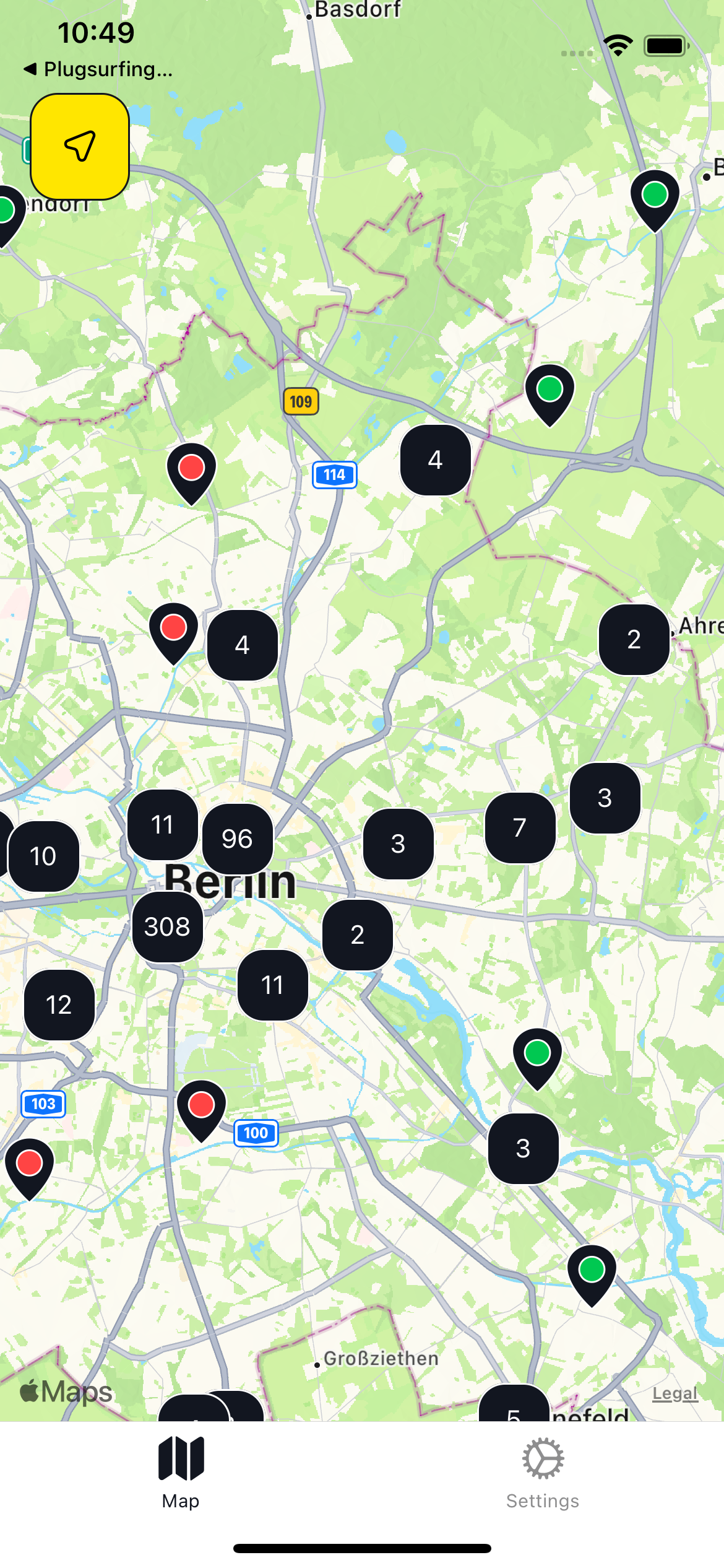
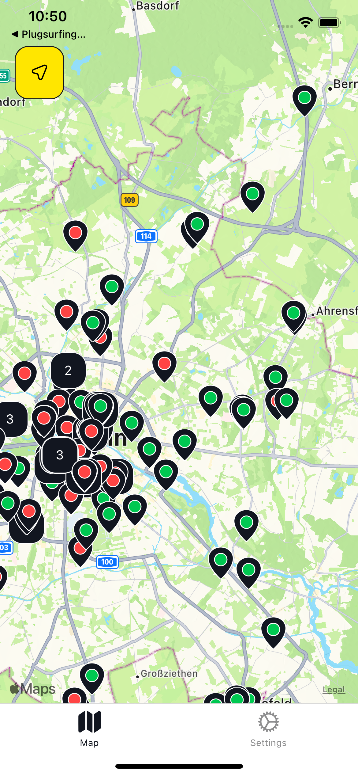
The easiest way to manipulate how tightly locations are aggregated is via the `K` constant, here you can see examples for different values. Different `K` values generate very different output, so adjust it to your application needs.
Example:
| K value | 0.000001 | 0.00001 | 0.0001 |
| - | - | - | - |
| Preview | 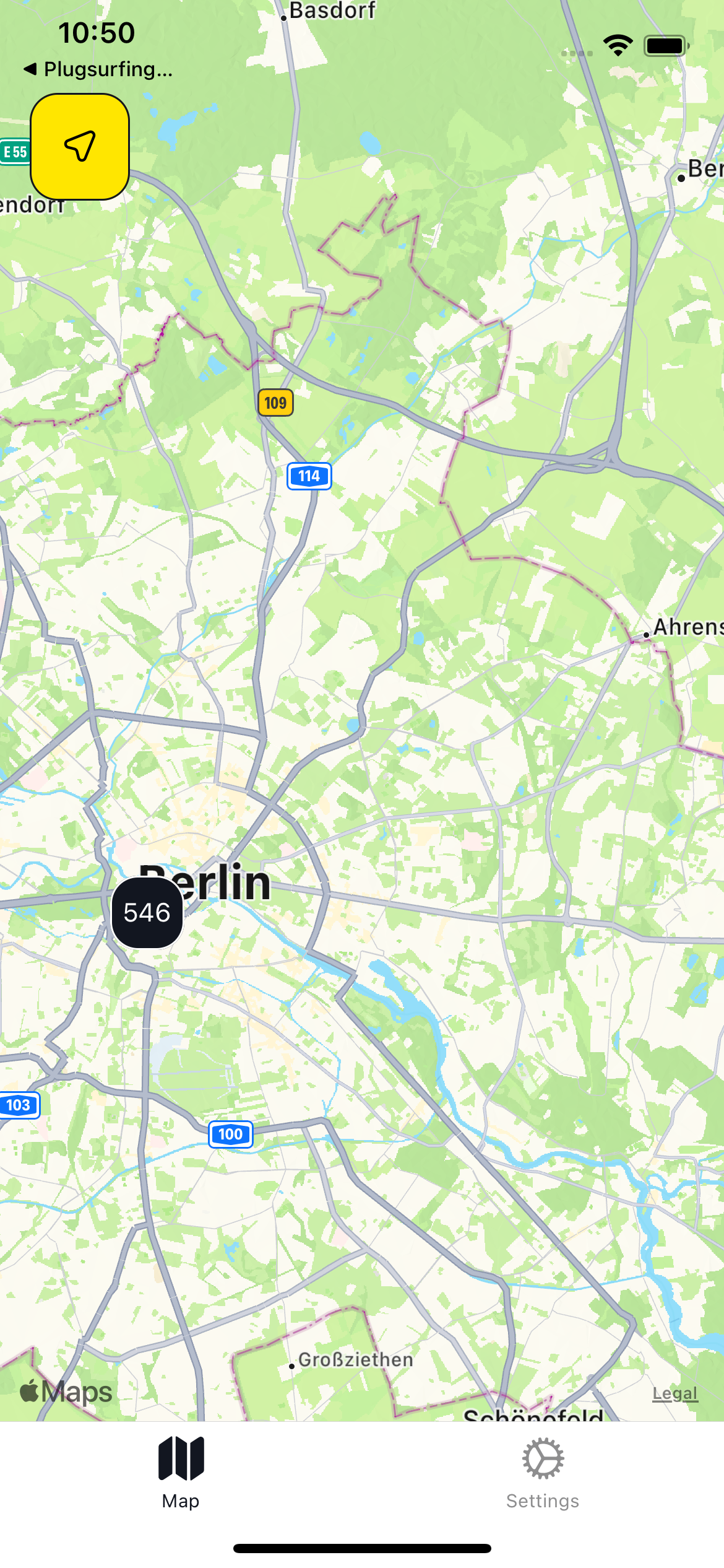 |
|  |
|  |
|
The last step is rendering the markers on map, this differs a lot between popular map libraries, but let's look at an example built with `react-native` and the `react-native-maps` library. We will render red pins for locations and blue pins for aggregations.
```tsx theme={null}
type LocationResponse = {
locations: Locations; // type for locations from Geosearch response
aggregates: Aggregates; // type for aggregations from Geosearch response
};
// set default state
const [response, setResponse] = useState({
locations: [],
aggregates: [],
});
const Map = () => {
const onRegionChangeComplete = async (region: Region) => {
// use getLocationsForRegion function showed before
const { locations, aggregates } = await getLocationsForRegion(region);
// set fetched locations to state
setResponse({
locations,
aggregates,
});
};
return (
// add onRegionChangeComplete event handler to fetch locations
// when user finishes moving map
{response.locations.map((location) => (
// render location markers
))}
{response.aggregates.map((aggregate) => (
// render aggregates markers
))}
);
};
```
> ❗
>
> This is just an example to show how to display locations as on a map, the Drive API is not meant to be called from client apps. Instead, it should be integrated on your backend, as described in [this page](/docs/introduction/getting-started#interaction-between-you-as-a-partner-plugsurfing-drive-api-and-the-charge-point-operators).
This documentation is built and hosted on [Mintlify](https://mintlify.com), a developer documentation platform.